

I've written extensively on how GIS can benefit Supply Chain & Logistics workflows. Some of the posts which you may refer are -
b) Mapping Workflows for Business Intelligence (Travel Accidents case within)
d) Supply Chain Network Design (Site Suitability Modeling using GIS case within)
In this article, you'll find two Case Videos on how Mapping Technology (GIS) can help to plan, analyze, monitor and communicate information pertaining to Public Transit (Transportation) Networks.
The videos are best viewed in YouTube's HD setting either on PC or on Landscape mode in Mobile Phone. You may reduce / increase the play speed as per your viewing preference
Case 1: Improving Bus Network Connectivity
Video Case: A city in Tennessee, USA wants to improve Bus connectivity for its residents by adding new bus stops and routes where the coverage is insufficient. In the video below, you'll see how I've used GIS to plot the existing Bus network, model the Service Areas (Coverage), overlay Demographic variables, compare iterations, evaluate potentially suitable zones generated by the model, and shortlist attractive sites for adding new Bus stops.
Video 1: Improving Bus Network connectivity
The methodology used here can be applied to non-Logistics workflows too - see an example here (Wildlife Habitat Zone identification).
Case 2: Visualizing the Expansion of Railway Network in 3D
Video Case: A city in California, USA has added a new Railway line connecting select neighborhoods in the Suburbs which have experienced an increase in housing growth to Downtown i.e. Central Business District. The 3D video depiction of the new Railway Line serves to educate the residents about the infrastructure development efforts being undertaken in the city and the reason behind choosing a particular zone for the new Railway line.
A 3D Map-based model was initially created which was subsequently converted into this video -
Video 2: 3D visualization of Railway Network & its Expansion
As you may infer from the two videos above, Mapping Technology (GIS) is very useful in analyzing and visualizing complex Public Transit Networks. There are several specialized modules available within GIS platforms which can aid in better planning and operations of Public Transit Networks - such as Safety Reporting, Project Dashboards, Traveller Engagement, and so on. Read more about it from this informative Story Map.

ABOUT US
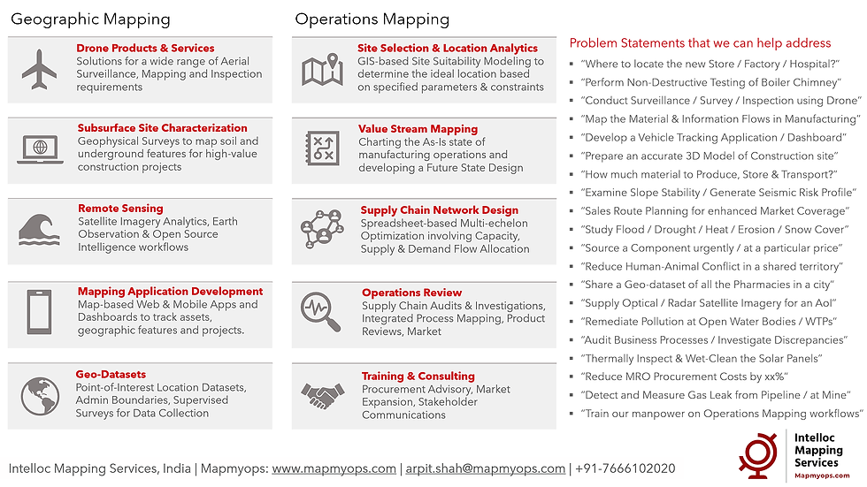
Intelloc Mapping Services | Mapmyops.com is based in Kolkata, India and engages in providing Mapping solutions that can be integrated with Operations Planning, Design and Audit workflows. These include but are not limited to - Drone Services, Subsurface Mapping Services, Location Analytics & App Development, Supply Chain Services, Remote Sensing Services and Wastewater Treatment. The services can be rendered pan-India, some even globally, and will aid an organization to meet its stated objectives especially pertaining to Operational Excellence, Cost Reduction, Sustainability and Growth.
Broadly, our area of expertise can be split into two categories - Geographic Mapping and Operations Mapping. The Infographic below highlights our capabilities.
Our 'Mapping for Operations'-themed workflow demonstrations can be accessed from the firm's Website / YouTube Channel and an overview can be obtained from this flyer. Happy to address queries and respond to documented requirements. Custom Demonstration, Training & Trials are facilitated only on a paid-basis. Looking forward to being of service.
Regards,
(The case has been analyzed using Esri's ArcGIS Pro. Much thanks to Learn ArcGIS. For informative purposes only)