Curiosity is a Android App where one can read educational content on interesting topics and satiate one's (unsurprisingly) curiosity. The App's homepage features five-seven new articles on a daily basis which refreshes every midnight. It has become my routine to read them before I go to sleep.
Curiosity occasionally features articles on mapping too. Here are FIVE interesting ones-
2023 Update: The Curiosity App has been shut down and hence, the hyperlinks initially embedded below wouldn't work. As a result, I've replaced the links with similar, publicly available information.

Yes, you've read it right! To rephrase it better, I'd say that 'a completely accurate World Map hasn't been created till date'. Each Map is a trade-off between the size of geographic features and the directionality of navigation between them. One often chooses the Projection based on the story / narrative that the creator wishes to convey using the map.
Read this to know why the rectangular-shaped AuthaGraph World Map is the unlikely contender for the most accurate World Map created thus far
This is the like the Mapping equivalent of Trap / Trick Questions often used in Surveys - a clever technique to know whether a the user's response is authentic or not. The technique in Maps is not too dissimilar - the creators insert fake locations in order to catch a plagiarist red-handed.
You'll also be surprised to know that the creator of Google Map Maker (it used to be a popular, collaborative Map editing tool) was an Indian - who also launched Google Maps in India subsequently. Read more here.
The solution to this challenge left me very surprised. Incredible to believe, yet true. In any multi-coloured World Map, you'd have observed that two adjacent regions are always colored differently - for demarcation purposes - it makes for effective Symbology.
So, in your opinion, what is the minimum number of colours that would be required to make a World Map where this principle remains intact? Tally your answer with the solution mentioned in the hyperlinked article!
Front contains Sweet receptors, Back contains Bitter receptors...remember? I actually used to suck at flavours of candies accordingly! This article changed that long-held belief.
The logic behind the finding is applicable to other scenarios as well; for example, why we must always take Research findings published in news reports with a pinch of salt. It is because Research is based on assumptions, degrees of confidence and sample sizes. They indicate a finding applicable within those Test parameters and are not necessarily, an accurate indicator of Real-Life outcomes.
Similarly, not until last year did I manage to know that the Map of India which we usually see, is not an accurate depiction of reality: The area that India actually governs is less - the erstwhile Jammu & Kashmir state is nowhere close to 'crown shaped' as it is commonly depicted. This is because we visualize disputed regions such as Pakistan-occupied Kashmir & Aksai Chin as our own even if in reality, we do not even have an iota of Governance there - it is governed by Pakistan and China respectively.
While the article will give you an overview of what was mapped out, this webpage contains the actual demonstration - you'll get it an instant!
No wonder, a Picture speaks louder than a Thousand words.
ABOUT US
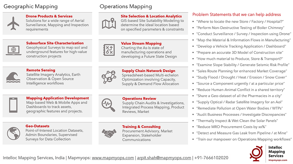
Intelloc Mapping Services | Mapmyops.com is based in Kolkata, India and engages in providing Mapping solutions that can be integrated with Operations Planning, Design and Audit workflows. These include but are not limited to - Drone Services, Subsurface Mapping Services, Location Analytics & App Development, Supply Chain Services, Remote Sensing Services and Wastewater Treatment. The services can be rendered pan-India, some even globally, and will aid an organization to meet its stated objectives especially pertaining to Operational Excellence, Cost Reduction, Sustainability and Growth.
Broadly, our area of expertise can be split into two categories - Geographic Mapping and Operations Mapping. The Infographic below highlights our capabilities.

Our 'Mapping for Operations'-themed workflow demonstrations can be accessed from the firm's Website / YouTube Channel and an overview can be obtained from this flyer. Happy to address queries and respond to documented requirements. Custom Demonstration, Training & Trials are facilitated only on a paid-basis. Looking forward to being of service.
Regards,

